Ground Control Points (GCP) & Check Shots in Pix4D

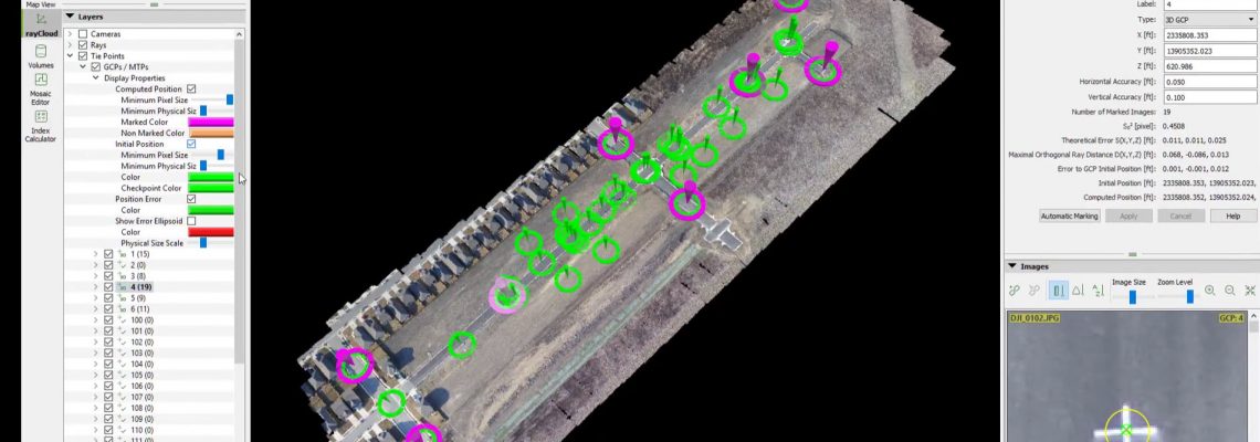
This video explains the difference between Ground Control Points (GCP) and check shots and how to use both of them within Pix4D Pro Mapper software to obtain survey grade accuracy Attributes of GCPs and Check Points GCPs are used to rotate, scale and orientate the project in a real world location or in some cases in a “Local Coordinate System) GCPs are typically statically placed around the outside edge of the project with at least one GCP in the interior of the project GCPs should not be more than 1,000-1,500 …
Read More

Drone Mapping Accuracy – Part II – Real Time Kinematics (RTK)

In an earlier post, we discussed Ground Control Points as a primary method of obtaining survey grade accuracy from drone mapping. The photogrammetry/mapping software (such as Pix4d Pro Mapper) uses these GCP to make adjustments to the project to obtain survey grade accuracy. However, this method requires laying out and precisely geolocating numerous control points (approximately every 1000 to 1500 feet). Depending on the terrain and/or the size of the project, the GCP method could be very impractical, difficult and time consuming. Another, arguably more advanced method, is referred to …
Read More

Vertical Aspect Inaugural Blog Post

As this is our inaugural blog posting, a little bit about our company…We’re Vertical Aspect – a small company of UAV Mapping experts – based out of San Antonio, while performing service work in Texas and surrounding We’re Vertical Aspect – a small company of UAV Mapping experts – based out of San Antonio, while performing service work in Texas and surrounding states, and providing UAV mapping training across the U.S. Our mission is to helping individual professionals and companies rapidly integrate drone mapping, through our …
Read More