Transform Ordinary Photos into Extraordinary Insights

Agisoft Metashape Professional converts photographs into precise 3D models, accurate measurements, and actionable geospatial intelligence. Whether you're mapping vast landscapes from above or capturing intricate archaeological artifacts up close, Metashape delivers professional-grade results with unprecedented ease and accuracy.

Agisoft Metashape Professional Edition is a comprehensive photogrammetry software that transforms ordinary photographs into precise 3D models, digital maps, and geospatial data. It processes various imagery types (aerial, satellite, close-range) and supports advanced workflows including LiDAR integration, multispectral analysis, network processing, and cloud-based operations. The software offers professional-grade tools for surveying, mapping, archaeology, cinematography, and large-scale infrastructure projects.

Why Professionals Choose Metashape

Unmatched Versatility
Process any imagery type—aerial surveys, satellite data, close-range photography, or ground-based captures. From archaeological documentation to infrastructure inspection, from cinematographic effects to precision agriculture, Metashape adapts to your unique workflow requirements.

Professional-Grade Accuracy
Built-in ground control point support, automatic camera calibration, and EPSG coordinate system integration ensure your results meet the highest surveying and mapping standards. Generate millimeter-precise measurements and georeferenced outputs that stand up to professional scrutiny.

Seamless Integration
Native LiDAR support, multispectral processing capabilities, and comprehensive API access (Python & Java) mean Metashape fits naturally into your existing workflows. Export to 50+ formats or integrate directly with your GIS, CAD, and analysis tools.

Core Features

features_01.jpg

Photogrammetric Triangulation

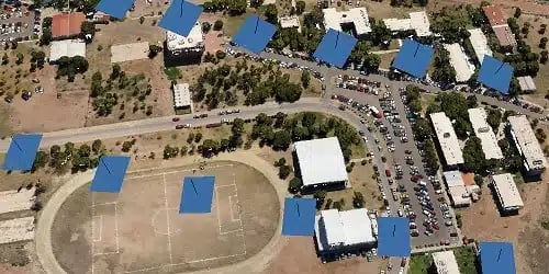
Process various types of imagery including aerial (nadir, oblique), close-range, and satellite imagery. Auto-calibration supports frame cameras (including fisheye), spherical and cylindrical cameras with multi-camera project support.

features_02

Dense Point Cloud Processing

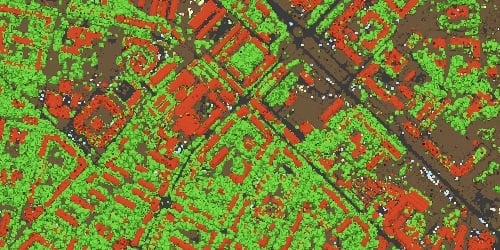
Generate and edit dense point clouds with elaborate model editing tools. Automatic multi-class point classification and import/export capabilities for seamless integration with classical point data processing workflows.

features_03.jpg

Digital Elevation Models

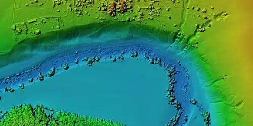
Create digital surface models (DSM) and digital terrain models (DTM) with advanced georeferencing based on EXIF metadata, flight logs, and GCP data. Full EPSG registry coordinate system support including WGS84 and UTM.

features_04.jpg

Georeferenced Orthomosaics

Generate high-quality orthomosaics in GIS-compatible GeoTIFF format with KML export for Google Earth. Features include color correction for homogeneous texture, built-in ghosting filter to combat artifacts from moving objects, and custom planar/cylindrical projections for close-range projects.

features_05.jpg

LiDAR Data Support

Comprehensive aerial LiDAR point attributes support with external registration capabilities for laser scans. Includes marker-based alignment of laser scans, visualization in Model view, and ground points classification specifically adapted for LiDAR data processing workflows.

features_06.jpg

Ground Control Points & Scale Bar Support

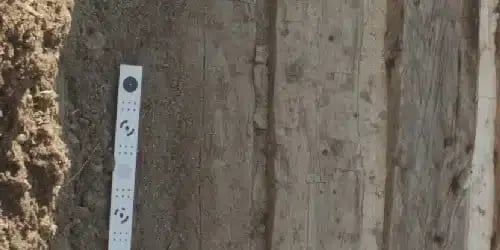
Import GCPs for precise georeferencing and accuracy control over results. Features coded/non-coded target auto-detection for fast GCP input, plus scale bar tools to set reference distances without requiring positioning equipment implementation.

System Requirements

Basic Configuration
up to 32 GB RAM (Laptop or Desktop)

CPU: 4 - 12 core Intel, AMD or Apple M1/M2 processor, 2.0+ GHz

RAM: 16 - 32 GB

GPU: NVIDIA or AMD GPU with 1024+ unified shaders (For example: GeForce RTX 2060 or Radeon RX 5600M)

Advanced Configuration
up to 128 GB RAM (Desktop or Workstation)

CPU: 6 - 32 core Intel or AMD processor, 3.0+ GHz
(For example: Intel i7 / i9 or AMD Ryzen 7 / Ryzen 9 / Threadripper)

RAM: 32 - 128 GB

GPU: 1 - 2 NVIDIA or AMD GPUs with 1920+ unified shaders. (For example: GeForce RTX 3080 or Radeon RX 6800 XT)

Extreme Configuration
128+ GB RAM (Server)

For processing of extremely large data sets a dual-socket Intel Xeon or AMD EPYC based servers (3.0+ GHz) with Quadro, Tesla, Radeon Pro or Instinct GPUs can be used.

Start transforming your projects today 

From precision measurements to stunning visualizations, discover why Metashape is the tool that bridges the gap between photography and professional analysis.