Phoenix miniRANGER-3 LITE

Survey-Grade LiDAR. Ultra-Lightweight.

Phoenix LiDAR's flagship compact airborne LiDAR system. 2-3.5 cm RMSEz at 75 m AGL, 300 kHz PRR delivering 300,000 measurements per second, 5-return capability, 360-degree horizontal FOV, and 2.5 kg total system weight with camera. Flies on the Freefly Astro Max, DJI M350, Alta X, and more. Optional 61 MP Sony ILX-LR1 photogrammetry simultaneous acquisition. 

2 -3.5cm

RMSEz Accuracy
@ 75 m AGL

300 kHz

Max PRR
300,000 meas./sec

83 pt/m²

Point Density
75 m AGL / 300 kHz / 6 m/s

5

Max Returns
IP64 / 905nm Class 1

PLATFORM ENGINE

Built for Professional LiDAR Programs

The Phoenix miniRANGER-3 LITE integrates the LiDAR sensor, navigation system, and optional imagery camera into a single unit. Every component — IMU, GNSS, scan engine, and camera — is pre-calibrated and validated as a system before delivery.

LiDAR ENGINE

miniVUX-3UAV / 300 kHz

RIEGL miniVUX-3UAV laser scanner at 100, 200, and 300 kHz pulse repetition rates. Up to 300,000 measurements per second. 360-degree horizontal FOV (reduced to 180 at 200 kHz / 120 at 300 kHz). 5-return capability for full vegetation penetration. 170 m effective range at 20% reflectivity / 290 m at 60%. 905nm Class 1 eye-safe laser.
 
RIEGL miniVUX-3UAV / 300k meas./sec / 5 returns
NAVIGATION

Air NavBox / IMU-27

Weight-optimized Air NavBox with dual-antenna GNSS and IMU-27 inertial measurement unit. GPS + GLONASS + BeiDou + Galileo multi-constellation. Kinematic and dual-antenna alignment supported. 1 cm + 1 ppm RMS horizontal position. 0.003° RMS roll/pitch and 0.011° RMS heading post-processed accuracy.

IMU-27 / Dual-antenna / 0.003° roll/pitch RMS
IMAGERY

61 MP Sony ILX-LR1 Option

Optional Sony ILX-LR1 (61 MP) for simultaneous LiDAR and high-resolution photogrammetry up to 100 m operating altitude. A6K-Lite (24 MP) single oblique option also available. Adds 0.95 kg to system weight (total 2.5 kg). Camera triggered and geotagged from the navigation system for accurate photo positioning without separate PPK processing.

61 MP ILX-LR1 / 24 MP A6K-Lite / Geotagged
SOFTWARE

LiDARMill Cloud Processing

Phoenix's LiDARMill cloud-based post-processing platform automates trajectory computation, point cloud generation, and deliverable output without requiring dedicated desktop processing software or deep LiDAR expertise. Upload raw data, configure output parameters, and receive calibrated LAS files. Scales to fleet operations without proportional processing overhead.

Cloud-based / Automated / LAS output
INTEGRATION

Custom Vibration Isolator Mounts

Phoenix provides custom vibration isolator mounts for validated UAV platforms including the Freefly Astro Max and DJI M350. Mounts are pre-engineered for the correct CoG position and vibration isolation characteristics for each aircraft — eliminating IMU contamination from rotor harmonics and maintaining sensor accuracy at operating flight speeds.

Astro Max / DJI M350 / Pre-engineered mounts
DEPLOYMENT

UAV / Backpack / Vehicle

The miniRANGER-3 LITE is designed for multi-platform deployment without sensor reconfiguration. The same LiDAR unit mounts to UAV, backpack, and vehicle platforms using platform-specific mounting kits. Survey teams operating mixed-mode programs (aerial and ground) carry one sensor across all data collection modes, maintaining calibration consistency and simplifying workflow.

UAV / Backpack / Vehicle — one sensor
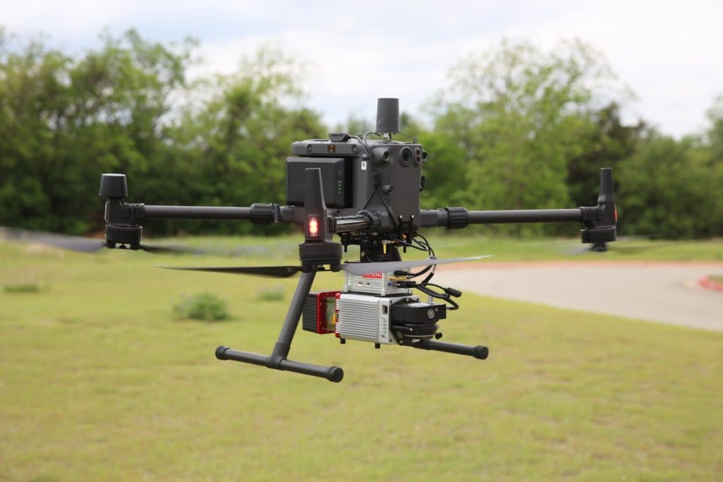
DJI-M300-IMG_9792-1-1024x683
DJI M350 INTEGRATION

3x Point Density. Same Proven Airframe.

The miniRANGER-3 LITE mounts directly to the DJI M350 RTK via a custom Phoenix vibration isolator — the highest number of target echoes per laser shot available on the M350 platform. RIEGL laser precision, Air NavBox navigation, and 300 kHz PRR deliver 83 pts/m² at 75 m AGL across 150 m swath widths. Same lightweight 2.5 kg system weight as the previous generation, with a 3x increase in point density that changes what's achievable at survey speeds.

Custom vibration isolator  |  DJI M350 validated  |  83 pts/m² @ 75m AGL  |  5 returns / 2.5 kg
IMAGING OPTIONS

LiDAR-Only or LiDAR + Imagery

Three configurations matched to program requirements. LiDAR-only for pure point cloud programs, A6K-Lite for oblique imagery at lower cost, and Sony ILX-LR1 for simultaneous 61 MP photogrammetry alongside LiDAR data collection.

LiDAR Only

Base System

No camera / 1.55 kg LiDAR

LiDAR Sensor

RIEGL miniVUX-3UAV

Camera

None

LiDAR Weight

1.55 kg

Power (typical)

30 W

Dimensions

24 x 13 x 18 cm

Best for

DTM, corridor, utilities

LiDAR + Oblique Imagery

A6K-Lite

24 MP single oblique

LiDAR Sensor

RIEGL miniVUX-3UAV

Camera

Sony A6K-Lite (24 MP) 

LiDAR Weight

2.5 kg 

Power (typical)

38 W 

Dimensions

30 x 13 x 18 cm 

Best for

Corridor + oblique reference 


LiDAR + 61 MP Photogrammetry

Sony ILX-LR1

61 MP / RTK geotagged

LiDAR Sensor

RIEGL miniVUX-3UAV

Camera

Sony ILX-LR1 (61 MP) 

LiDAR Weight

2.5 kg 

Power (typical)

38 W

Dimensions

100 m AGL (photogrammetry) 

Best for

Survey + ortho / simultaneous 


MISSION APPLICATION

Where the miniRANGER-3 LITE Works

Survey-grade accuracy at ultra-lightweight form factor across UAV, backpack, and vehicle platforms. The miniRANGER-3 LITE is designed for programs where operator portability, multi-platform deployment, and survey-class deliverables are all required.

01

Utility Corridor Mapping

Powerline, pipeline, and transmission corridor survey at 75 m AGL, 150 m swath width, 3.24 km²/hr collection rate. 5-return capability enables full vegetation penetration for conductor sag, vegetation encroachment, and right-of-way clearance analysis in a single pass.

02

Rail Track Mapping

Sub-3 cm intraswath precision for track geometry analysis, clearance profiling, and asset inventory. UAV acquisition over active track — backpack or vehicle for depot, yard, and inaccessible segments. One calibrated sensor across all three acquisition modes.

03

Open Pit Mining

High point density at survey-grade accuracy for stockpile volumetrics, highwall mapping, and haul road monitoring. 83 pts/m² at 75 m AGL delivers the point cloud density needed for accurate volume calculations across complex pit geometries.

04

Oil and Gas

UAV acquisition over pipeline and facility corridors for integrity monitoring, encroachment detection, and as-built surveying. Multi-platform flexibility enables access to areas where UAV flight is restricted — switching to backpack or vehicle without sensor reconfiguration.

05

Agriculture and Forestry

5-return point clouds for vegetation structure analysis, canopy height modeling, and biomass estimation. Optional 61 MP simultaneous imagery for crop health monitoring alongside DTM and DSM generation. LiDARMill cloud processing delivers outputs without dedicated post-processing expertise on site.

06

Construction Surveying

Regular-interval site progress surveys with repeatable accuracy. 2-3.5 cm RMSEz enables reliable cut/fill volume tracking, as-built verification, and structural monitoring. Backpack mode for interior or under-structure access — UAV for site-wide coverage in a single flight.

Ready to deploy the miniRANGER-3 LITE?