Phoenix LiDAR's most versatile survey-grade LiDAR system. 1200 kHz PRR delivering up to 185 pts/m² at 100 m AGL. 490 m max operating altitude at 20% reflectivity. 15-return capability. 360° horizontal FOV. 1550 nm Class 1 laser at 10 mm sigma accuracy. The same RANGER FLEX unit installs on UAV, VTOL, helicopter, vehicle, and backpack without reconfiguration. Optional 61 MP removable camera. Powered by Phoenix LiDARMill cloud processing.
Every technical decision in the RANGER FLEX serves the survey team that operates across multiple platform types and terrain conditions: 1550nm laser for maximum range, 15-return waveform for dense vegetation, and the RANGER FLEX DUAL MOBILE accessory for simultaneous dual-head mobile scanning.
RIEGL 1550nm laser at selectable 50 to 1200 kHz PRR. 15-return capability enables maximum vegetation penetration for DTM extraction in forested corridors. 10 mm one-sigma range accuracy at 150 m. Class 1 eye-safe. 360° horizontal FOV from the single rotating mirror.
IMU-30 inertial measurement unit with 0.002° RMS roll/pitch and 0.007° RMS heading post-processed accuracy. GPS + GLONASS + BeiDou + Galileo multi-constellation. Static, kinematic, and dual-antenna alignment modes supported. 1 cm + 1 ppm GNSS baseline RMS horizontal position. Real-time and post-processed operation modes.
61 MP RGB camera available as a removable option for UAV applications. Adds 1.2 kg to system weight (total 5.9 kg with camera). Camera geotagged from the GNSS/IMU system for accurate photo positioning. Removable design allows LiDAR-only configuration for vehicle and backpack deployments where camera weight impacts maneuverability.
The RANGER FLEX unit installs directly into the RFM1 (single) or RFM2 (dual) mobile mapping accessory without modification. Dual-head RFM2 configuration delivers simultaneous two-sensor scanning for maximum point density and shadow elimination in urban canyon, underpass, and complex infrastructure environments at full vehicle speed.
LiDARMill cloud platform automates trajectory processing, point cloud generation, and LAS output without dedicated desktop software. SpatialExplorer provides real-time 3D visualization during acquisition and full post-processing with calibration and analytical tools. Phoenix FlightPlanner for mission optimization and sensor configuration before flight.
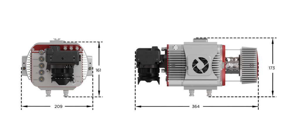
RANGER FLEX: 4.7 kg / 27.9 x 20.9 x 17.3 cm. RANGER FLEX with camera: 5.9 kg / 36.4 x 20.9 x 17.3 cm. 14-28 VDC input. 75W typical power (85W with camera). Operating temperature 0°C to 40°C. Dedicated mounting kits for each platform type — UAV, VTOL, helicopter, vehicle, and backpack — all included in platform-specific accessory packages.
SYSTEM ACCURACY
All accuracy figures from Phoenix LiDAR's published test conditions (February 2026 spec sheet). RMSEz measured at 120 m AGL, 90° downward FOV, using PLS recommended acquisition and processing workflow and ASPRS checkpoint guidelines.
CM RMSEz
Vertical Accuracy
@ 120 m AGL / 90° FOV
CM RMSDz
Intraswath Precision
@ 120 m AGL / flat / >20% reflectivity
° RMS
0.007° RMS Heading
Post-processed / IMU-30
+ 1PPM RMS
Horizontal Position
GPS + GLONASS + BeiDou + Galileo
The RANGER FLEX is the only system in Phoenix's lineup that installs on UAV, VTOL, helicopter, vehicle, and backpack without reconfiguration. For survey teams operating multi-platform programs — aerial for large-area coverage, mobile for corridor detail, backpack for access-restricted areas — the RANGER FLEX eliminates the need to own, calibrate, and maintain multiple sensors. One system. One calibration. Every acquisition mode.
1200 kHz PRR, 490 m max AGL, 15-return capability, and five deployment platforms make the RANGER FLEX the right sensor for survey programs spanning aerial, ground, and access-restricted environments.
Aerial acquisition with UAV or VTOL at 180 m AGL / 400 kHz for 360 m swath coverage at 33 km²/hr. Mobile mapping on vehicle for access road and structure detail. 15-return waveform enables conductor sag and vegetation encroachment analysis through dense canopy in a single pass.
Mobile mapping vehicle at 40 km/hr for track geometry, clearance profiling, and asset inventory at 1,700 pts/m². Backpack for depot, yard, and inaccessible segments. Aerial UAV for corridor-level overview. One sensor, consistent calibration, three acquisition modes.
Dual-head RFM2 mobile configuration for highway corridor mapping at full vehicle speed. High lane point density for pavement condition index, sign inventory, and as-built survey. Aerial UAV for interchange, overpass, and complex interchange geometry where ground access is restricted.
High-density UAV acquisition at 185 pts/m² for stockpile volumetrics and cut/fill progress monitoring. Mobile mapping for site road and structure as-built. Backpack for interior slab, formwork, and areas where UAV operations are restricted by crane or structure height.
1.5-3.0 cm RMSEz at 120 m AGL for cadastral, topographic, and large-area terrain modeling. 490 m max AGL enables VTOL or helicopter deployment for very large area surveys at survey-grade accuracy. LiDARMill cloud processing delivers LAS output without dedicated post-processing infrastructure.
360° FOV dual-head RFM2 configuration at 1,700 pts/m² for urban canyon, facade, and streetscape mapping. Simultaneous two-sensor scanning eliminates shadow zones between buildings. Combined aerial and mobile program with one sensor delivers both site-level and corridor-level deliverables from a single mobilization.
Vertical Aspect provides full sales support and platform integration guidance for the Phoenix LiDAR RANGER-UAV22 FLEX.
Contact us to discuss your survey requirements, platform options, and configuration.


Geospatial solutions for surveying and mapping professionals — hardware, software, and field-tested workflows.
Want more information?
1520 Clay Street
Kansas City, MO 64116
© 2026 Vertical Aspect LLC. All Rights Reserved.