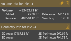
• Home
  • About Us
    • Vertical Aspect Team
    • Vertical Aspect Offerings
  • Products
    • Pix4D Pro Mapper
    • Robota Eclipse
    • Virtual Surveyor
  • Services
    • Aerial Imagery Services
    • Training
    • UAV Consulting
    • UAV Mapping Services
  • Gallery
    • Video Gallery
  • Our Blog
  • Resources
    • UAV Mapping Apps & Links
    • Frequently Asked Questions
    • Presentations
    • Training Videos
    • Financing & Credit
    • Sitemap
  • Contact Us

Gallery

Go to Video Gallery
  • All
  • 3D Maps
  • Aerial Mapping
  • Flight Plans
  • Inspections
  • Ortho Images
  • Other Maps
  • Pix4D Outputs
  • Pix4D & Other Product Info
  • Ranches & Real Estate
  • Topography Maps
  • UAV Training
Loading Images
Aerial Mapping, Pix4D Outputs, Topography Maps
Quarry-Elevation-model2
Quarry Elevation Model
P4Pro - Loki PPK
Loki_Logo
Loki_Inspire-Mount-sm
Pix4D & Other Product Info
GeoCue_landinglogo-new
3D Maps
320 Check Shots comparisonV2
320 Check Shots Images
NO-GCP
Loki Screenshot
320 Check Shots Images-0000
loki-system
Website Design-Misc
FinanceIt-Ascentium
future is automated
Future Automated
AAPG Explorer Magazine article
4. foto2-Robota
Apps-iPhone
sitemap2
RobotaEclipseCase-Bluefoam
Pix4D & Other Product Info
RobotaEclipse_case
Robota Eclipse with Sony Payload
Pix4D & Other Product Info
Robota-Sony-Payload2
Robota Eclipse with FLIR
Pix4D & Other Product Info
FLIR-TAU2
Robota Eclipse - Feb 2017
Pix4D & Other Product Info
Robota Eclipse Feb 2017
Robota Eclipse with Micasense RedEdge Camera payload
Eclipse - Rededge Camera
Robota Eclipse-bottom
RTK Variants graphics3
RTK Variants graphics2
GCP - Check Point - Screen Shot 2
GCP - Check Point - Screen Shot 1
UAV Training
IMG_4999
UAV Training
IMG_4879
UAV Training
IMG_4043
UAV Training
IMG_4037
Inspections, Ranches & Real Estate, UAV Training
IMG_2376
Inspections, UAV Training
IMG_0975
Globa-Mapper_logo
What is RTK
RTK - 3. Virtual Reference Station
RTK - 2. Unknown Position
RTK - 1. Known Position
Robota Eclipse
Robota Eclipse
Microsoft_Surface
Inspire Flight Simulator
UAV Training
Pix4D_screenthot
Robota GCS 2
Pix4D-Aerial
Pix4D & Other Product Info, Pix4D Outputs
Pix4D_screenthot
Components for Drone...
Part107
Microsoft_Surface
MapPilot_Screenshot
MapPilot_Screenshot
GCP-Zoom Out
GCP-Zoom In
GCP-Without GCP
GCP-Text File
GCP-Measure-RTK Rover
GCP-Good-Spray Painted
GCP-Good-Numbered
GCP-Good-Folding-reversible
GCP-Good-Commercially Available
GCP-Good-Ceramic Tiles
GCP-Bad-Not Flat
GCP-Bad-Blurry
GCP-Bad-Ambiguous Center
GCP Placement
Pix4D & Other Product Info, UAV Training
GCP-With GCP
DRONE MAPPING ACCURACY
Vertical Aspect on KSAT-12
UAV Training
Drone Mapping Overview
3D Maps, Ortho Images, Topography Maps, UAV Training
B2_14.-Viewshed2
Aerial Mapping
b2_18-accident2
Aerial Mapping
b2_17-accident1
b2_16-terrain2
b2_15-terrain1
b2_14-viewshed2
b2_13-viewshed1
b2_12-oil_field
b2_11-parking-lot
b2_10-bridge_inspection
b2_09-3dmodel-house
b2_08-construction_site
b2_07-slope_directions
b2_06-contour_lines
b2_05-volume-area-calc
b2_04-volume-calc
b2_03-photo-ortho
b2_02-photo_stitching
b2_01-ortho
facebook-header-va2
innovators-in-technologies
aapg-tweet-pic
creditcardlogos
Vertical Aspect FAQs
faq_icon
blog2-volumecalc
blog2-volume2
blog2-viewshed2
blog2-viewshed
blog2-slopedirections
blog2-realestate
blog2-parking-lot
blog2-ortho1-2-3combined
blog2-oilfield
blog2-modifyterrain
blog2-inspections
blog2-contours
Aerial Mapping
blog2-accidentreconstruction2
Aerial Mapping, Other Maps
blog2-accidentreconstruction1
blog2-volume2
Blog1-part107
Blog1-Mapping-made-sense
Blog1-TakingOff
Blog1-drone-path2
Website Design-Misc
Vertical Aspect
VS Volume Measurement
Pix4D & Other Product Info
VS Volume measurement table
VA Stockpile-showing
VS Stockpile - Removed
VA Stockpile-removed
VS-Screenshot-400k
Virtual Surveyor 3.3 screenshot
VS 3.3 Screenshot
VSLogo_fm_Brochure
P4Pro
3D Maps, Ranches & Real Estate
Conaway aerials-6
Large Estate
CCR aerials-10
Lakeside Ranch
Virtual Surveyor
Virtual Surveyor - Breaklines & Triangulation
SurveyGrid1
VS-Breaklines
Robota Eclipse
Robota Eclipse
FF_Robota_LO_400x400
logo-59a5cf8d
pasted image 400x255
image_la series
image003
CaseOut
Aerial Mapping
BasePoint
Web_rx100
Web_Micasense
Maleta_Eclipse
Goose_aparato
GCS_Tablet
Pix4D & Other Product Info
foto-Robota
foto2-Robota
Pix4Dmapper-Logo-RGBweb-large-black
Aerial Mapping, Other Maps
Accident Reconstruction-2
Tennis Mosaic-Ortho & 3D Mapping
Ortho Images
Tennis-Mosaic
Tennis Mosaic-Aerial & 3D Mapping
Quarry-Ortho & 3D Mapping
Ortho Images
Quarry0-Aerial & 3D Mapping
Aerial & 3D Mapping
Quarry Point Cloud
Aerial Mapping, Ortho Images
Quarry-point_cloud
Quarry Point Cloud-
Aerial Mapping
quarry-ortho
Quarry Ortho-Aerial & 3D Mapping
3D Mapping & Ortho Images
Aerial Mapping, Ortho Images
Quarry-mosaic
Aerial Mapping
quarry-mosaic large
3D Mapping & Ortho Images
Ortho Images
Quarry-Image Capture
Ortho Images
James-10 Ray Cloud
Ortho Images
Hull-Inspire-150'
Ranches & Real Estate
27052
Ranches & Real Estate
27052-28
Ranches & Real Estate
27052-23
Opiela Drainage
Topography Maps
Stockpile-point DSM
Aerial Mapping, Topography Maps
quarry-volume_extraction
Aerial Mapping, Topography Maps
quarry-terrain_modelling
Aerial Mapping, Topography Maps
Quarry-dsm_with_scale
Topography Maps
quarry-contour_line_extraction
Quarry - Elevation model
PIX4D Mapping
Topography Maps
contour_lines
26995-10
26995-01
Ranches & Real Estate
26293s
Ranches & Real Estate
26293p
Ranches & Real Estate
26293o
Ranches & Real Estate
26293c
Ranches & Real Estate
26293b
Ranches & Real Estate
26293
G0272716
Ranches & Real Estate
DCIM100GOPRO
DCIM100GOPRO
Ranches & Real Estate
DJI00212
Ranches & Real Estate
DJI00176
Ranches & Real Estate
DCIM100GOPRO
DCIM100GOPRO
24765u
24765k
Ranches & Real Estate
13181921-27
Ranches & Real Estate
13181921-25
Ranches & Real Estate
13181921-20
Ranches & Real Estate
13181921-14
Ranches & Real Estate
13181921-5
Ranches & Real Estate
13181921-2
Ranches & Real Estate
13181921-1
Ortho Images, UAV Training
James-10-partial
Ortho Images, UAV Training
james 10-no overlay
Ranches & Real Estate, UAV Training
27052-22
Ranches & Real Estate, UAV Training
27052-12
Ranches & Real Estate, UAV Training
27052-11
Ranches & Real Estate, UAV Training
27052-08
UAV Training
Sensefly eBee
UAV Training
Sensefly Icon
UAV Training
Sensefly ebee aerial mapping
UAV Training
postflight
UAV Training
Postflight terra1
UAV Training
Postflight terra
UAV Training
Phantom v2+
UAV Training
P2v with battery and controller
UAV Training
Inspire with dual controllers
UAV Training
Inspire side shot
UAV Training
elOnSide-postflight
UAV Training
Inspire 1 controller with ipad
UAV Training
DJI pilot screen shot
UAV Training
DJI vision app screen shot
UAV Training
26995
Ranches & Real Estate, UAV Training
26995-18
Ranches & Real Estate, UAV Training
26293f
Ranches & Real Estate, UAV Training
26293a
Ranches & Real Estate, UAV Training
DCIM100GOPRO
DCIM100GOPRO
Ranches & Real Estate, UAV Training
24765h
Ranches & Real Estate, UAV Training
13181921-24
Ranches & Real Estate, UAV Training
13181921-15
Aerial Mapping, Pix4D Outputs
Houston-volume
Pix4D Outputs
dsm_with_scale
Pix4D Outputs
Digitized Orthomosaic
Pix4D Outputs
Digitized Ortho without image
Aerial Mapping, Pix4D Outputs
CAD-Terrain
Aerial Mapping, Pix4D Outputs
CAD-Ortho
Aerial Mapping, Pix4D Outputs
Cad-densified_point_cloud
Aerial Mapping, Pix4D Outputs
CAD-contour_lines
Aerial Mapping, Pix4D Outputs
CAD-cadastre_kml
Aerial Mapping, Pix4D Outputs
CAD-cadastre_google_maps_tiles
Aerial Mapping, Pix4D Outputs
CAD-3d_pdf
Aerial Mapping, Pix4D Outputs
CAD-3d_pdf_p1
Aerial Mapping, Pix4D Outputs
cad-3d_mesh
Flight Plans
Tennis-Flt Plan
3D Maps, Aerial Mapping
Quarry-Flight Path and photo locations
Flight Plans
emotion SAT
Flight Plans
howland large google overlay
Custom Maps
UAVDirect-page-001
3D Maps
Quarry-ortho-zoomed
3D Maps
quarry-mosaic large
3D Maps, Ortho Images
Quarry-Image Capture
3D Mapping
3D Maps
Quarry-3D looking down
quarry-3D looking up
Inspections
DCIM104MEDIA
DCIM104MEDIA
Inspections
GOPR1433-Drone Inspections
Drone Inspections
Drone Inspections
Inspections
GOPR0264-C-Drone Inspections
Drone Inspections
Inspections
G0021862
Drone Inspections
Inspections
G0021861
Inspections
DCIM104MEDIA
DCIM104MEDIA
Inspections
DCIM104MEDIA-Drone Inspections
Inspections
DCIM104MEDIA
DCIM104MEDIA
Drone Aerial Mapping
Inspections, Ranches & Real Estate
DJI00671
Aerial Mapping, Pix4D Outputs, UAV Training
CAD-DTM
Aerial Mapping, UAV Training
CAD-cadastre_mapbox
Aerial Mapping, Pix4D Outputs, UAV Training
cad-3d_point_cloud
UAV Training
3d_textured_mesh
Flight Plans, UAV Training
Houston-Ray Cloud
Custom Maps, UAV Training
West_Nixon-page-001
3D Maps, UAV Training
Quarry1
3D Maps, Ortho Images, UAV Training
Quarry0
3D Maps, UAV Training
Quarry-point_cloud
Quarry Flight Path
3D Maps, UAV Training
Quarry-Flight Path and photo locations
Inspections, UAV Training
IMG_2191
Drone Inspections & UAV Training
Inspections, UAV Training
DCIM100GOPRO
DCIM100GOPRO-Drone 3D Mapping, Inspections, and UAV Training
Inspections, UAV Training
DCIM100GOPRO
DCIM100GOPRO-Drone 3D Mapping, Inspections, & UAV Training
Drone Inspections and UAV Training
Inspections, UAV Training
G0072002-Drone Inspections & UAV Training
Drone Inspections and UAV Training
Inspections, UAV Training
G0011810
Drone Inspections and UAV Training
Inspections, UAV Training
G0011788
Inspections, UAV Training
G0011800
Inspections, UAV Training
G0011783-Drone Inspections and UAV Training
Inspections, Ranches & Real Estate, UAV Training
DJI00204-Drone Inspections
LA-300 Fixed WIng
MapsMadeEasy-SHORT.mp4
3D Fly Thru-Blue Star-SHORT.webmhd
Aerial Mapping
eBeeFlying-SHORT
3D Fly Thru-Blue Star-SHORT.webmhd
Inspire_TakeoffLanding-SHORT.webmhd
KespryFlyover-SHORT.webmhd
Videos
Hull_Ranch_3d-SHORT
KSAT 12 News Segment-SHORT.webmhd
MapsMadeEasy-SHORT.webmhd
TildenPipeline-SHORT.oggtheora
Virtual Surveyor
hi-res transparent-21
DroneViewTech_Logo
SurveyGrid1
Opiela Drainage
quarry-3D looking up
Aerial Mapping
Quarry1
Aerial Mapping
Quarry0
Aerial Mapping
Quarry-point_cloud
Aerial Mapping
3D Maps, Aerial Mapping
Quarry-Flight Path and photo locations
Aerial Mapping
Ortho Images
Quarry-Image Capture
Aerial Mapping
quarry-mosaic large
Aerial Mapping
Quarry-ortho-zoomed
quarry-3D looking up
Aerial Mapping
Quarry-3D looking down
Pix4d-proMapper-Logo
050627-N-0295M-021
050627-N-0295M-021 
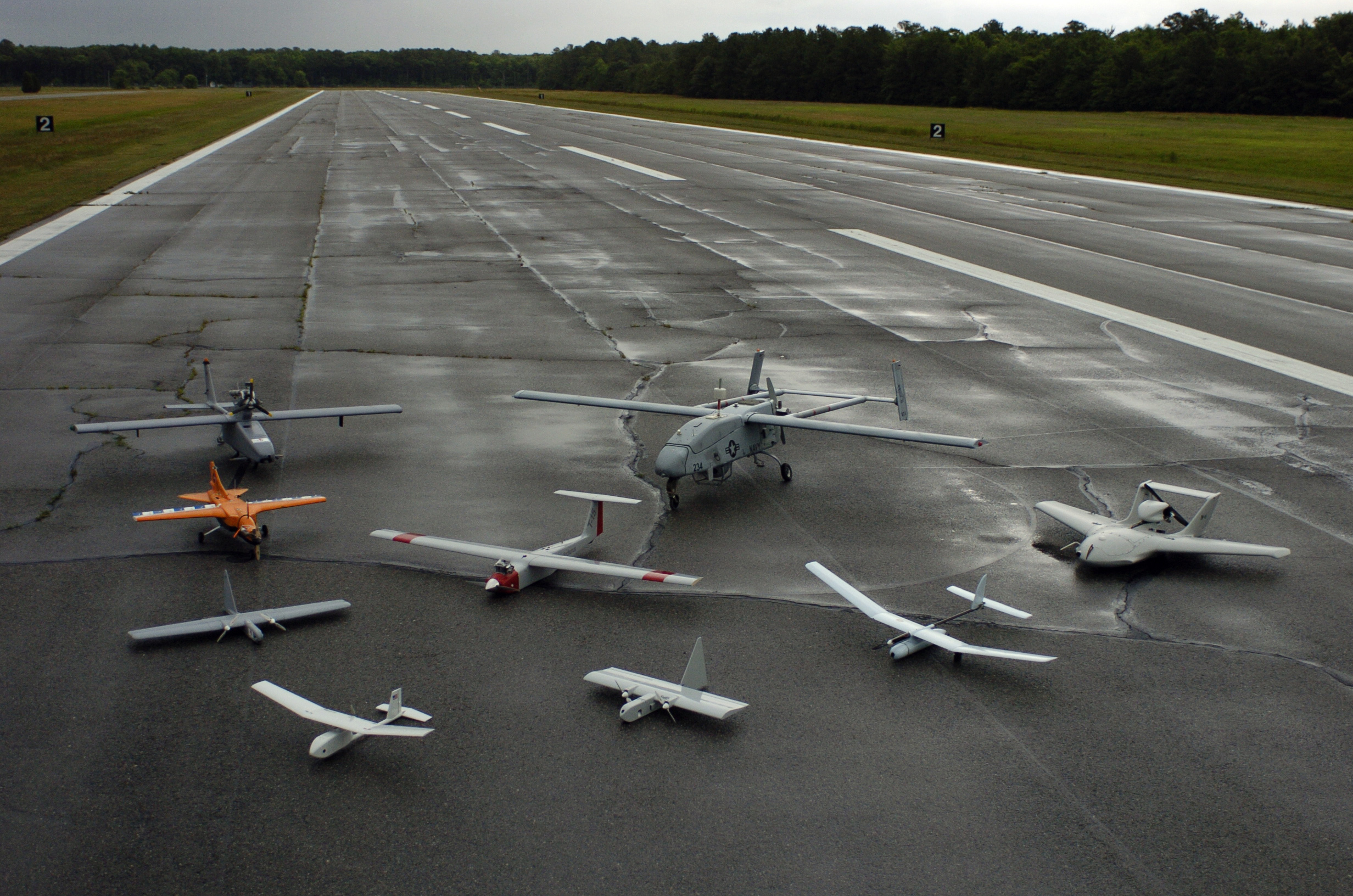
St. Inigoes, Md. (June 27, 2005) Ð A group photo of aerial demonstrators at the 2005 Naval Unmanned Aerial Vehicle Air Demo held at the Webster Field Annex of Naval Air Station Patuxent River. Pictured are (front to back, left to right) RQ-11A Raven, Evolution, Dragon Eye, NASA FLIC, Arcturus T-15, Skylark, Tern, RQ-2B Pioneer, and Neptune. The daylong UAV demonstration highlights unmanned technology and capabilities from the military and industry and offers a unique opportunity to display and demonstrate full-scale systems and hardware. This yearÕs theme was, ÒFocusing Unmanned Technology on the Global War on Terror.Ó U.S. Navy photo by PhotographerÕs Mate 2nd Class Daniel J. McLain (RELEASED)
Pix4D & Other Product Info
Create-Fly-Through-Animation
Aerial Mapping, Pix4D & Other Product Info
AirGon-logo

© 2023 VERTICAL ASPECT, LLC · support@verticalaspect.com · (210) 896-3384

  • Home
  • About Us
    • Vertical Aspect Team
    • Vertical Aspect Offerings
  • Products
    • Pix4D Pro Mapper
    • Robota Eclipse
    • Virtual Surveyor
  • Services
    • Aerial Imagery Services
    • Training
    • UAV Consulting
    • UAV Mapping Services
  • Gallery
    • Video Gallery
  • Our Blog
  • Resources
    • UAV Mapping Apps & Links
    • Frequently Asked Questions
    • Presentations
    • Training Videos
    • Financing & Credit
    • Sitemap
  • Contact Us